This crossing of Ash Creek looked deep but it was only fast-moving.
This crossing of High Creek or Harrison Creek? was too deep and rocky for little Jeep!


This crossing of High Creek or Harrison Creek? was too deep and rocky for little Jeep!

The creek in Coronado Camp area.

Looking east to the Pinaleno Mountains.

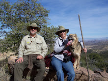
Great day for a drive! Headed out with Dave,Barb and Red towards Willcox, all paved roads until we turned off at Bonita. Along the way we passed the many greenhouses(hydroponic tomatoes) and apple and pecan orchards. This valley lies between the Pinaleno and Galiuro Mountains and reminds us of southern Ontario farming. The mountains were topped with an abundance of snow and the streams were running. We had to cross the various creeks 4 times. After passing thru Sunset(don't blink) which had no sign, just a few vacant buildings, we came upon a Coronado National Forest camp area,had lunch and did some exploring. We tried to travel into the forest but the creek was too much of a challenge. From there we returned to Bonita(only a few houses and a vacant mercantile building) we headed down hwy 266 across lower section of the Pinaleno mountains. We found a 4x4 road and did some exploring in to a very picturesque valley. We returned to Benson via hwy 191 and 10. What a great day!